Interactive Eclipse Map
So, now the total solar eclipse that crossed the United States on August 21, 2017 is history. Whether or not you experienced totality, it's already time to look ahead to the next ones that will touch the U.S.
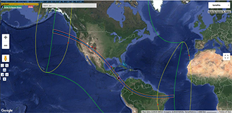
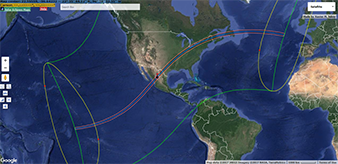
French eclipse-chaser and mapmaker Xavier M. Jubier has plotted the path for you using Google Maps, and he’s allowed me to reproduce his work. Just click on one of the maps to the left.
When you access either map, you’ll be able to zoom in and out (use the bar at the left edge) or move back and forth (click, hold the mouse button down, and move) until you locate your ideal spot.
The green line shows the limits of where the eclipses will be partial. The two pink lines show the northern and southern limit of totality. And the ever-so-important blue line is each eclipse’s center line.
Google Maps has the drop-down menu at the top right so you can change the view from “Satellite” to “Map.” You even can add “Terrain” to the “Map” view.
Using these amazing maps, you’ll be able to answer the question, “Where will you be the next time the light goes out in the U.S.?”